Wednesday, June 9, 2010

- Enmore

- Another village of significant importance in Guyana is Enmore. It was one of the five villages that pooled together and bought the village of Vitoria. It is located in the region of Demerara-Mahaica, East Coast Demerara and about 30 minutes from Georgetown. The Atlantic Ocean neighbours it to the north; and large sugarcane fields just beyond its southern horizon. This village is about two square miles in size, with a multi-ethnic population of about 8,000, mainly indo-Guyanese.


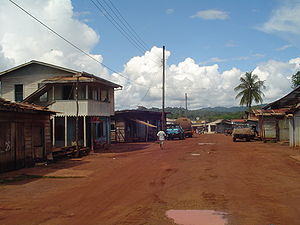
Founded in the late 1940’s, where residents from a village to the south-east was granted plots of land there to start this new community. These plots of land were an improvement from the historic mud huts houses of the old village. The new era brought is better cultivation of fruits and vegetables, and was consistent as the village grew.


Enmore is significantly known for the Enmore Martyrs, who were killed during a labour dispute in 16th June, 1948. These men that died are namely, Lallabagee Kissoon, Pooran, Rambarran, Dookhie and Harry. They were shot during a strike, demanding the abolishment of the existing “cut and load” system in the fields. They passed away different days and it is said that Harry died in an actual fight with the shooters. An annual memorial day is held in Enmore in remembrance for these five brave men, on 16th June.


- Mahdia


Madhia is located in the Potaro Siparuni region, very small but very beautiful. It has a population of approximately 4000, including residents from its nearby Amerindian village of Campbell Town, a community which is governed by a village council with a Toshau at its helm. Mahdia is also made of three groups of people namely the Patamonas Amerindian tribe, the Coastlanders, who are residents from elsewhere in Guyana but resides in Mahdia, and the Islanders who are immigrants mainly consisting of people from the Caribbean islands, particularly, St. Lucia and Dominica. Mahdia is accessible by road from Bartica, the Konawaruk road and from Georgetown, via a pontoon crossing on the Essequibo River at Mango Landing. An airstrip is also available for small planes. Persons wishing to travel from Georgeown can take 72 minibuses, with a trip that will take between 5 to 8 hours, depends on the weather and road/trail conditions.


This small town is the regional administrative centre of region 8 and its has a hospital, an airstrip, one nursery, a primary and secondary schools, a commercial sector which includes dry goods’ shops, boutiques, a fuel station, two hotels and a brothel. It also has a police station with a small prison, and regional democratic council.


An annual celebration, in August, is held in Mahdia, a cultural event which usually attracts thousands of persons to the bustling community, where, according to Bell development has progressed rapidly over the past decade.


- New Amsterdam

New Amsterdam is located in the East Berbice –Corentyne region of Guyana, 62 miles from Georgetown. Its four miles upriver from the Atlantic Ocean mouth of the Berbice River, on its eastern bank, immediately south of the Canje River. It’s one of the largest towns in Guyana with a population of approximately 33,000. Persons who wish to take a trip to this town do so by taking a 50 bus from the park, which takes roughly about 2 hours. There are also taxis available. There are many scenes to see while on this long trip.

New Amsterdam was formerly known as Niew Amsterdam. Initially, in 1784 the Dutch had decided to move their seat of Government to the confluence of Berbice and Canje Rivers and here the town of New Amsterdam was born. It got its new name from the Dutch, because at that time most of the shareholders were from the province of New Amsterdam in Holland.

The present town is fairly small that consists of three main roads. One Mayor and a thriving market. The schools in New Amsterdam are Berbice High school, Berbice Educational Institute, Vryman’s Erven Secondary, Tutorial Academy and New Amsterdam Multilateral High School (opened in 1975).

There is also an open public ground called Esplanade west of the Esplanade road and immediately opposite the Gardens. It brings back a lot of memories of times when it was once a popular picnic resort and a place where the people of Berbice met.


The following are old buildings thats are no more or reconstructed into new ones. 

Mission Chapel Congregational Church in the 1950s

A panoramic view of Strand, New Amsterdamin the 1920


New Amsterdam Public Hospital in  1950


A view of  a Dry Goods & Provision Store inNew Amsterdam


The New Amsterdam Postal Service in the 1940s


New Amsterdam C


The Governor’s House


A Dry Goods Store in New A


A panoramic view of Queenstown, New Amsterdam


A view of Strand, New Amsterdam in the 1950s


A day in the Town of New Amsterdam


     in the 1950s


New Amsterdam Waterworks


A view of Peter Chung Tiam Fook’s Dry
Goods & Provision Store in
New Amsterdam


The New Amsterdam 


Government Quarters, New Amsterdam (1950)


New Amsterdam Town Hall(1950)


The New Amsterdam Public Hospital


Mission Chapel Congregational Church


All Saints Scots Church


Ituni Temple:


The New Amsterdam Town Hall